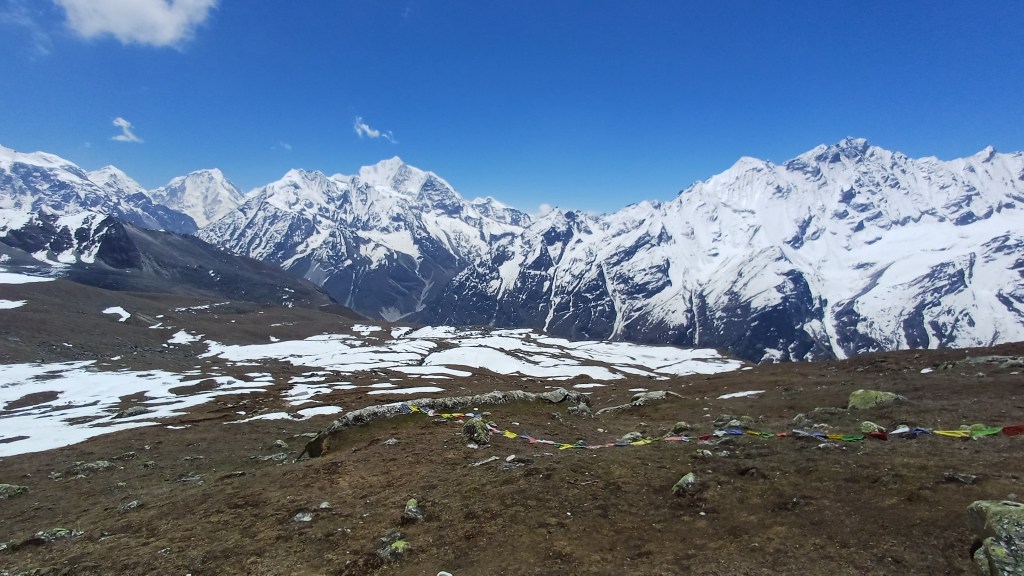
A stage-by-stage guide to the demanding one-day hike from Kyanjin Gompa in Nepal’s Langtang Valley to the summit of Tserko Ri (also spelled Tsergo Ri or Cherko Ri) at about 5,000m. Summary: a long, strenuous high-altitude hike but, in clear weather, the panoramic mountain views from the summit are exceptional
Route in: trek from Syabrubesi to Kyanjin Gompa
Start point: hike from anywhere in Kyanjin Gompa east up the Langtang Valley, along the western ridge of the mountain and up its final north-western slope to the summit
Route out: the simplest navigational option is to retrace the outward route. I instead descended east from the summit, then turned south and west across the slopes north of the Langtang River until I rejoined the outward path. A route was visible for most of the descent but there were loose scree sections and the line may be difficult to follow in snow, cloud or poor visibility.
Map link: https://www.alltrails.com/explore/custom-routes/tsergo-ri-44d4526
Time: round trip took me 9 hours: 5 hours up, 1.5 hours at the summit, 2.5 hours down. I am moderately fit but well past the bloom of youth, and times will vary considerably with fitness, acclimatisation, weather, snow, etc. Whenever you go and unless you are just there for your social media feed, plan to spend some time at the summit absorbing the view.
Grading: this is a hike not a scramble so not graded. It was hard work: 12km and 1,300m of ascent mostly at altitudes above 4,000m.
Acclimatisation: this is essential. I spent 1.5 days at Kyanjin Gompa before this hike including climbing Kyanjin Ri the previous day. This is personal context, not a recommended acclimatisation schedule.
Start time: start early. In retrospect, I would aim to reach the summit for sunrise but this requires a much earlier departure and navigation in darkness and possibly breaking trail across deep snow. Only consider this with suitable conditions, reliable navigation, an adequate headtorch and current local advice.
Warning: the path is often steep and occasionally with moderate drops on each side; beware of weather (sun, rain, snow, wind) including sudden changes; take care across scree slopes on the return leg. Snow or ice can significantly change the difficulty and may obscure the path. Check current conditions locally before setting out and be prepared to turn back.
Gear: standard full-day hiking gear including good boots, hiking poles, spikes for snow fields at many times of year, plenty of sun protection, warm and windproof layers, and more water than you think you’ll need
Verdict: in clear weather, the views at the top are absolutely spectacular; one of the most amazing places I have ever been
Category: Hike
Score: 9/10
Video guide:
Map:
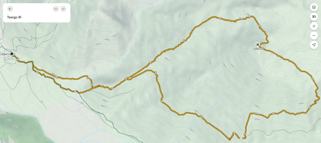
Map image/data from OpenStreetMap via AllTrails

Leave a comment