
Guide to hiking to the top of Matmora on Austvågøya in the Lofotens. Summary: a pretty epic day out with amazing views and some challenging hiking; only recommended in good weather
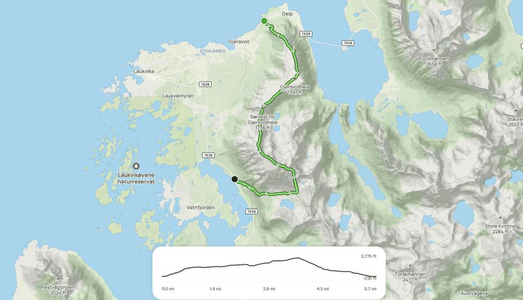
Route in: drive to the car park just west of Delp (lat, long: 68.40130, 14.50271) with alternative parking in a lay-by around 250m further west
Start point: through the gate at the south end of the first parking spot
Mid point: Matmora summit
Route out: you could retrace your route in from Matmora back to Delp but the AllTrails route sends you east then south then west from the summit, and then walking back to Delp along the Midnattsolveien/7638 road
Map link: https://www.alltrails.com/en-gb/trail/norway/nordland/topptur-over-delpen-og-matmora
Time: the overall route took me 7 hours: 4 hours up to Matmora, 1.5 hours down, and then 1.5 hours back along the road (another time, I’d try hitching a lift)
Grading: this is a hike not a scramble so not graded, but you will need a little grade 1 scrambling in a couple of places. It was a substantial day out: 4 miles and 2,500 feet of ascent to get up Matmora, 2 miles and 2,500 feet of descent down to the road, 4 miles along the road
Note 1: there can be fabulous views of Grunnførfjorden and the mountains and sea beyond from the Delpen plateau that is part-way along the marked AllTrails route. But if you just wanted to climb Matmora, it would make more sense to park at 68.35997, 14.48190 (marked as ‘Matmora Hiking Trail’ on Google Maps) and go up and down the final part of the AllTrails route: just 4 miles up and down in total.
Note 2: as indicated in the video, I’m not sure the lateral (more-westerly, lower) path that I took is easier and safer than the path on top of the cliff edges that follows the AllTrails marked route
Note 3: if you don’t fancy the cliff edges, on a nice day, you can just walk up to the Delpen plateau and back, enjoying the views it offers
Warning: this hike is one thing in good weather; very different in poor weather – sharp drops to wander off if visibility is poor (and with no views in poor visibility, why would you bother), significant exposure if windy, and slippery boulder surfaces in places if wet. Check the weather forecast: https://www.yr.no/en. You will need a certain head for heights: see video for examples
Gear: standard long-day hiking gear
Verdict: really recommended if the weather is good because of the fantastic views and the challenge of the hike; if you like less challenge and just want the summit panorama, take the short option from the Matmora Hiking Trail start point; if you like even less challenge, just hike up to the Delpen plateau
Category: Hike
Score: 8/10
Video guide:
Map:
Map image/data from OpenStreetMap via AllTrails

Leave a comment